Is a 9.2 EarthQuake Cascadia really on is on its way?
There is a common belief that Juan de Fuca Plate will force itself hard
enough against the North Atlantic Plate to cause a 9.2 earthquake. So, last week, when my daughter messaged the family with a link to a Fox News, I started laughing so hard, my wife thought there was something wrong.
According Shepard Smith of Fox News , a "stunning" article run in the New Yorker said that a 9.2 mega quake was "on its way" and would be spurred on when the Juan de Fuca Plate supposedly causes the North American Plate to rupture -- all along a 700 mile length of the Cascadia subduction zone to finally give in and let the Juan De Fuca Plate to slide underneath it.
Well, it isn't going to happen. Why? Because it happened in Japan in 2013 on the Pacific Plate which goes from the Juan De Fuca Plate to the Eurasian Plate is expanded along with the Juan De Fuca Plate by magma.
History of the 9.0+ quake can be found here.
Only problem is, the Pacific Plate slides more on the west side than it does on the east side. If you think about it, it makes perfectly good sense. One, the moon has an effect on plane movement rising and lowering the surface mantle and pulling it towards the west.
Take a look at the map below. You can see where the Juan de Fuca Plate
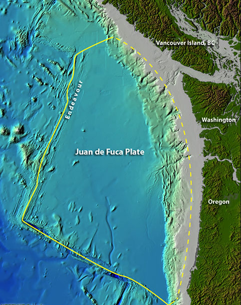
If you follow the edge where the ocean floor where the plate is sliding under the earth above, where this is going along smoothly, the edge appears sharp and detailed. But right about the spot where the word Oregon is, the nice sharp line becomes dull and in some places, barely recognizable.
In fact, right where the Columbia River it appears that the plate hasn't moved for centuries.
Also, at the top of this picture, closer to the land, you can see what looks like squares and rectangles

To someone like myself who lived through the Seattle 6.8 back in 2001 and I've learned a lot about earthquakes, seismographs and activity at Mount Rainer and Mount Saint Helens.
While I'm no geologist, I did point out that it looked like Mt Saint Helens was about to remind us once again that it was still an active volcano -- despite the fact that it blew its top in 1980.
When two plates fuse together, you get Mount Everest.
Okay let's go back to the two sheets of paper. Overlap them again and then place a pin in the center of it and then push the top sheet until the paper begins to buckle. Remove the pin.
Congratulations, you just created a paper scale earthquake and a tsunami no seismograph will every record and nobody died.
But it is how major Earthquakes happen.
So what causes this to happen?
Like pushing the paper, a crack in the crust enables lava to come to the surface and this new magnum becomes part of the Juan De Fuca Plate.

Every year, Juan De Fuca Plate slips under the North American. Sometimes it is more noticeable than other times. February 25th, 2017 an article announced that it was noticeably slipping . Here's the link.
The Juan De Fuca Plate is actually a set of plates
It is the Juan De Fuca Plate which caused the earthquake that I experienced but not the actual 9.2 potential is under the Subduction Zone itself.
Aside from being able to produce earthquakes, the Subduction Zone also builds the scenic mountain chains area between Portland and British Columbia and feeds the volcanoes with new Magma --what some geologists call product.
It also has created an environment between the mountain chains that is more humid and --I personally hate this one --rainier than other places in the US.
But put two people behind the vehicle and push it past the incline and over the top...you have the same effect as a rupture or a mega quake.
Okay, so what does a Seismograph show us that we don't know after living through one?
Here's what the 6.8 quake that I was in looked like:
 This is a "clipped" view of it. Saves money on ink and is less scary looking. Here's a more colorful version.

So what happens when a large earthquake hits? As I recall, the first thing I remember is what sounded like a low flying jet in full power mode trying to climb. Then the windows started to rattle, after that, tiles fell from the ceiling and someone shouted earthquake while my computer and monitor decided on their own to move about on my computer desk at Lincoln Plaza, Bellevue, Washington while working for Microsoft.
There are technical terms like P Wave and S Wave. If you're interested, you might look them up.
What I will say is, go to a pond where the water is still, get yourself a large rock and throw it out into the water. You will hear the sound of the rock hitting the water, but you won't see the water waves come to the edge where you are with the rock being thrown out 25 feet away. Do the same a lot closer and the separation between sound and the ripples getting to your shorten.
This seismograph was 20 and 30 miles away from the Epicenter. A computer analysis would be 100% sure. I'm eyeballing.
After that, the land like the water rings move across the earth surface looking a lot like the rings you would see on the pond.
Our cell phones didn't work. I went home to check up on my family.
It was then that I realized, the Puget Sound area is a real disaster waiting to happen.
A 9.2 makes that 6.8 a dress rehearsal for kindergartners.
Here's a map:

According Shepard Smith of Fox News , a "stunning" article run in the New Yorker said that a 9.2 mega quake was "on its way" and would be spurred on when the Juan de Fuca Plate supposedly causes the North American Plate to rupture -- all along a 700 mile length of the Cascadia subduction zone to finally give in and let the Juan De Fuca Plate to slide underneath it.
Well, it isn't going to happen. Why? Because it happened in Japan in 2013 on the Pacific Plate which goes from the Juan De Fuca Plate to the Eurasian Plate is expanded along with the Juan De Fuca Plate by magma.
History of the 9.0+ quake can be found here.
Only problem is, the Pacific Plate slides more on the west side than it does on the east side. If you think about it, it makes perfectly good sense. One, the moon has an effect on plane movement rising and lowering the surface mantle and pulling it towards the west.
Take a look at the map below. You can see where the Juan de Fuca Plate

If you follow the edge where the ocean floor where the plate is sliding under the earth above, where this is going along smoothly, the edge appears sharp and detailed. But right about the spot where the word Oregon is, the nice sharp line becomes dull and in some places, barely recognizable.
In fact, right where the Columbia River it appears that the plate hasn't moved for centuries.
Also, at the top of this picture, closer to the land, you can see what looks like squares and rectangles

To someone like myself who lived through the Seattle 6.8 back in 2001 and I've learned a lot about earthquakes, seismographs and activity at Mount Rainer and Mount Saint Helens.
While I'm no geologist, I did point out that it looked like Mt Saint Helens was about to remind us once again that it was still an active volcano -- despite the fact that it blew its top in 1980.
How major earthquakes happen
If you take two pieces of printing paper, place one on top of the other so that they overlap, you what have an idea as to what a subduction does. And this can on either side of the two sheets of paper -- the one going over top of the other sheet of paper or the one going under the top sheet of paper.When two plates fuse together, you get Mount Everest.
Okay let's go back to the two sheets of paper. Overlap them again and then place a pin in the center of it and then push the top sheet until the paper begins to buckle. Remove the pin.
Congratulations, you just created a paper scale earthquake and a tsunami no seismograph will every record and nobody died.
But it is how major Earthquakes happen.
The Pressure is on!
So what causes this to happen?
Like pushing the paper, a crack in the crust enables lava to come to the surface and this new magnum becomes part of the Juan De Fuca Plate.

Every year, Juan De Fuca Plate slips under the North American. Sometimes it is more noticeable than other times. February 25th, 2017 an article announced that it was noticeably slipping . Here's the link.
The Juan De Fuca Plate is actually a set of plates
It is the Juan De Fuca Plate which caused the earthquake that I experienced but not the actual 9.2 potential is under the Subduction Zone itself.
Aside from being able to produce earthquakes, the Subduction Zone also builds the scenic mountain chains area between Portland and British Columbia and feeds the volcanoes with new Magma --what some geologists call product.
It also has created an environment between the mountain chains that is more humid and --I personally hate this one --rainier than other places in the US.
Anything we can count on?
While earthquakes are not as predictable as sunsets and sunrises, some events appear to have a historical trend to them. Juan De Fuca Plate slips every 14 months. But not in the direction you might think. It actually moves towards the Pacific Plate. Kind of like what would happen if you pushed a car on a slight incline, stopped pushing, got out of the way and let the car roll back to where it was.But put two people behind the vehicle and push it past the incline and over the top...you have the same effect as a rupture or a mega quake.
Okay, so what does a Seismograph show us that we don't know after living through one?
Here's what the 6.8 quake that I was in looked like:

So what happens when a large earthquake hits? As I recall, the first thing I remember is what sounded like a low flying jet in full power mode trying to climb. Then the windows started to rattle, after that, tiles fell from the ceiling and someone shouted earthquake while my computer and monitor decided on their own to move about on my computer desk at Lincoln Plaza, Bellevue, Washington while working for Microsoft.
There are technical terms like P Wave and S Wave. If you're interested, you might look them up.
What I will say is, go to a pond where the water is still, get yourself a large rock and throw it out into the water. You will hear the sound of the rock hitting the water, but you won't see the water waves come to the edge where you are with the rock being thrown out 25 feet away. Do the same a lot closer and the separation between sound and the ripples getting to your shorten.
This seismograph was 20 and 30 miles away from the Epicenter. A computer analysis would be 100% sure. I'm eyeballing.
After that, the land like the water rings move across the earth surface looking a lot like the rings you would see on the pond.
Our cell phones didn't work. I went home to check up on my family.
It was then that I realized, the Puget Sound area is a real disaster waiting to happen.
The best case scenario in a worst case situation
None of us back in 2001 were prepared for or trained for a 6.8 earthquake.A 9.2 makes that 6.8 a dress rehearsal for kindergartners.
Here's a map:

Don't rely on anything or anyone. If land or sea transportation is not available, a four place flying vehicle with vertical takeoff and range of is the only option you will have for your personal and loved one's safety and security. Most of them fly themselves and have the ability to be programmed so that they don't rely on GPS but on visual cued ground positioning.
Comments
Post a Comment